|
| Home
> All
About Bali > District
> Tabanan |
| |
| Tabanan |
| |
 |
| |
| Demography |
Tabanan covers 839,30 square km
of land. It is divided into 10 sub-districts: Baturiti,
Penebel, Pupuan, Marga, Selemadeg, Kerambitan, Tabanan,
Kediri, Selemadeg Barat, and Selamadeg Timur, with
Tabanan as the capital city.
The primary sector in Tabanan regency is agriculture.
Around 50% people working in this sector while others
are in commercial and industrial sectors. |
| |
| Geography |
Geographically, Tabanan regency
as strategic position because it borders on Jembrana
regency in the west, Buleleng regency in the north,
Badung regency in the east, and Indian Ocean in
the south.
Tabanan regency comprises two main regions: the
mountains and the lower plains. The Tabanan highlands
mostly consist of volcanic areas, with Mount Batukaru
(2275m), Mount Sanghyang
(2093m), and Lake Bratan.
|
| |
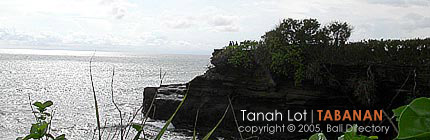
| Places of Interest |
| Tabanan has lots of well-known tourism
area such as Tanah Lot Temple, Klating Beach, Soka
Beach, Bedugul, Alas Kedaton and other areas that
are potential to be developed. |
| |
| |
| |
|
|